Overview
Features
Examples
References
Data-Sets
Download
  |
|
|
Terrain Fingerprint Features
Create\Enhance Terrain Data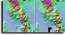
- Merge Bathymetric and Topographic DEMs together into a new DEM.
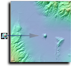
- Cut any size or dimension DEM section and Paste it into another DEM. Perform tilt, rotate, shift up and down operations on the pasted DEM.
- Save and Load any size or dimension DEM section for a future Paste.
- Roughen, and smooth the area for any shape DEM (whole, irregular, or rectangle).
- Modify DEM elevation values with a grid spreadsheet
- Create valley and ridge lines
- Create bathymetric terrain and streams
- Outline holes and mark elevation range as missing
- Re-interpolate data with new resolution using UTM or Latitude/Longitude defined spacing.
Repair Terrain Data
- Interpolate using Trend Surface or a reference DEM
- Automatically repair holes
- Roughen trend surface
- Show hole inventory
- Track terrain attribute changes to the area under repair
- Roughen, and smooth the area for any shape DEM (whole, irregular, or rectangle).
- Modify DEM elevation values with a grid spreadsheet
- Create valley and ridge lines
- Outline holes and mark elevation range as missing
- View repair in 3D model with quick-toggle before and after views
Terrain Fingerprint Terrain Matching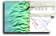
- Find statistically similar terrain using our default Terrain Fingerprint or tailor it to fit your own requirements.
- Match terrain based on terrain attributes or NLCD attribute data
- A map plot of US has all of matching terrain for user to choose from or best matching terrain can be automatically loaded.
 DEM Statistics
- Aspects by slope
- SSO Diagram
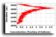
- Elevation histograms,
- Elevation/Slope plots
Analyze
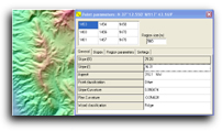
- Point parameters
- Map blowups
- Terrain Fingerprints
- Slope curvature correlations
- Point classifications
- Area parameters
- Terrain Fingerprint: Average elevation, average slope degree, terrain orientation strength, terrain fabric direction, and elevation relief ratio.
- General: Relief, s1s2, s2s3, terrain fabric direction, and elevation relief ratio, number of sample points, terrain shape, terrain strength, and roughness factor
- Moments: Elevation, slope1 (SAN,%), slope2 (ENU,%), slope3 (FCN,%), slope1 (SAN,°), slope2 (ENU,°), slope3 (FCN,°), slope2 (ENU,sine), slope convexity, and plan convexity cross-referenced to Average, Standard Deviation, Skewness, Curtosis, and number of sample points.
- DEM quality: Max slope, ghost ratio, source contours, Queens aspect ratio, pits, voids, edges, and number of sample points.
- Variogram: Gamma NS, Gamma EW, Gamma NESW, Gamma NWSE
- Graphs: Elevation histogram, variogram, NS MEM power spectrum, EW MEM power spectrum, SSO diagram, aspect distribution, slope convexity histogram, plan convexity histogram, percent slope histogram, degree slope histogram, percent slope method histogram, degree slope method histogram, elevation-slope plot, sine slope histogram, Moran 1, Q-Q plot elevation, Q-Q plot slope convexity, and Q-Q plot plan convexity
- Points: Percentage of simple peaks, ridges, valleys, quad peaks, quad ridges, quad valleys, quad passes, and quad pits.
Calculate
- Area
- Distance
- Slopes: slope, excessive slope,steep slope, and point slope
- Point parameters
- Bearing
- Geodetic bearing
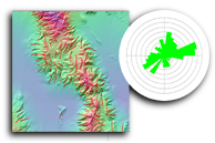
- Topographic grain: Topographic grain classification map, topographic grain vector overlay, and terrain fabric at a point
- Map window corners
- Point categories
- United States properties (geology, USGS Quad names)
- Derivative grid: slope %, slope degree, slope sin, aspect, profile convexity, plan convexity, cross sectional curvature, minimum curvature, maximum curvature, openness upward (positive), openness downward (negative), reflectance, custom terrain category, meter elevations, Ln transform elevations, Log 10 transform elevations
DEM Fingerprint and NLCD Atlas 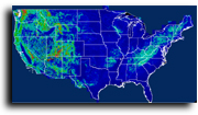
- View NLCD Atlas DEM and Terrain Fingerprint Atlas file.
- Graphically compare and perform terrain attribute grid correlations from USGS NED, USGS 1:24 10 meter level 2, 30 meter level 2, and 30 meter level 1, USGS NLCD, North American SRTM 1", and North American SRTM 3" Terrain Fingerprint data.
Printing
- HP Large format printing
- Print preview and Scaling
- Legend options for elevation color, scale bar, and titles
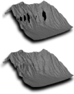
3D Modeling
- Selection of any size area
- Rotate and Translate the 3D model in any direction
- Zoom in and out
- Set vertical exaggeration
- Apply lighting azimuth and elevation
Display Options
- UTM and Latitude\Longitude Grids
- Elevation map, Slope map, Reflectance map, Contour map, Aspect map, and DEM color merge map
Vector Overlay
- Overlay ESRI shapefiles, DXF, SIN format, SDTS DLG, Latitude/Longitude Points, and VPF Table and Coverage.
- Overlay Database (*.dbf) files with full filtering and display support
Data Sets included with Terrain Fingerprint Workstation
- Data Cabinet puts all of available data on one map, allowing user to select on the data necessary.
- Data Cabinet downloads only data necessary from DVD.
- Automatically overlay State, County, TIGER, and Gazetteer data based on map resolution.
- Create database index for fast loading
Supported DEM formats
SDTS
GeoTIFF
USGS BIL
Golden Software Surfer Grid
NED binary or gridfloat
MicroDEM
DTED
ASCII XYZ
DEM Index
NGDC GRD98
NOS EEZ Bathymetry
GLOEBE
GTOPO30
SRTM30
SRTM Heightfield
USGS ASCII CDO
OS 5 or 20 km tile
BC Grid
VTP BT
|