Overview
Download
 |
|
|
About the USGS Data Sets
USGS NED and NLCD Data Set Bundle
USGS National Elevation Dataset and National Land Cover Data nationwide coverage. The NED format is USGS BIL with a final size of 25 GB compressed. Delivered on six DVDs. The NLCD format is GeoTIFF with a final size of 1.6 GB compressed. Deliver on single DVD.
North American SRTM 1" Data Set
North American SRTM nationwide coverage. USGS BIL format with a final size of 17 GB compressed. Delivered on four DVDs.
South American SRTM 3" Data Set
COMING SOON! South American SRTM nationwide coverage. USGS BIL format. Delivered on one DVD.
Custom Digital Elevation Model Data Set
Specify a particular area, and data requirements, and we will be more than happy to supply all of your DEM data requirements. USGS NED, USGS 1:24 10 meter level 2, 30 meter level 2, and 30 meter level 1, USGS NLCD, North American SRTM 1", South American SRTM 3", TIGER, and Gazetteer nationwide coverage. Worldwide SRTM data will be released as it becomes available. Available in any public format and delivered on the medium of your choice.
NLCD Atlas DEM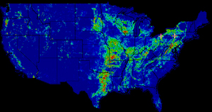
For each:
Open Water
Perennial Ice/Snow
Low Intensity Residential
High Intensity Residential
Commercial/Industrial/Transportation
Bare Rock/Sand/Clay
Quarries/Strip Mines/Gravel Pits
Transitional
Deciduous Forest
Evergreen Forest
Mixed Forest
Shrubland
Orchards/Vineyards/Other
Grasslands/Herbaceous
Pasture/Hay
Row Crops
Small Grains
Fallow
Urban/Recreational Grasses
Woody Wetlands
Emergent Herbaceous Wetlands
|
|