Overview
Features
Examples
References
Data-Sets
Download
  |
|
|
Terrain Fingerprint Overview
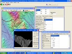
 Terrain Fingerprint Workstation
Digital Elevation Model data creation, enhancement, diagnostics, and repair using the Terrain Fingerprint database.
Supports all common DEM formats including ESRI ArcGIS, Golden Software Surfer, and MicroDEM. Each workstation
comes with the USGS NED and NLCD Data Set Bundle, NLCD Atlas DEMs, Gazetteer 2003, and TIGER 2000 data.
Terrain Fingerprint Lite is also available for download.
The Terrain Fingerprint Workstation has the technology to uniquely
characterize terrain with a number of important benefits:
 |
Create terrain data or a sub-section of a terrain data set to perform
terrain analysis under very specific statistical conditions
Interpolate missing data that faithfully reproduces the character of
the surrounding terrain from a DEM source including an emerging
DEM source such as the Shuttle Radar Topography Mission
(SRTM)
|
Create, enhance, or repair terrain data that accurately models specific geographic attributes, with grid
resolution and fidelity while maintaining complete statistical control over the data set
Run diagnostics to determine how different collection methods, data spacing, and processing methods affect the ability to calculate the key geomorphic parameters and to obtain accurate DEMs
Predict accuracy degradation with respect to terrain data set scale/resolution and understand the accuracy limitations of the DEM data derived from the source
Because Terrain Fingerprint utilizes the degree of terrain organization when characterizing terrain, our approach for creating and enhancing terrain data is superior to any current techniques in areas where the desired terrain has steep slopes, shadows, forests, or in snow and ice fields.
Each Terrain Fingerprint Workstation comes with the USGS NED and NLCD Data Set Bundle, NLCD Atlas DEMs, Gazetteer 2003, and TIGER 2002 data nationwide coverage.
Compatible with ESRI ArcGIS®, Golden Software Surfer®, and MicroDEM digital elevation model formats.
|